What flying apps are you using on Android Tablets and phones, free or otherwise?


What flying apps are you using on Android Tablets and phones, free or otherwise?
Bartman
Retired USAF
Kitfox 5
N617BR
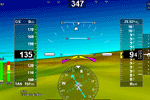
here are a few that I know of: Naviator-the one I currently use, reasonably priced(I pay $34 a year for the app with sectionals,and as I recall you can get it for $14 a year with a simple base map with no sectionals) and works well , but is not being supported by its creator and hasn't been updated for about a year,although map and data updates are still available.
Avare- a free app that I tried but had too many bugs and not enough info and ADSB in data was sketchy. You get what you pay for.
Droid EFB-don't know nuthin about it
Flt plan go-same as above
I will continue to use naviator until something better comes along at a good pricepoint. My big complaint right now with the app is that due to lack of admin support , updates to the new ADSB weather features that the FAA put out last summer are not being implemented.
I would like to hear what others are using as well to see what's out there
Bruce N199CL

I am using an IFLY gps/screen for NAV which has a $69 per year subscription for the US sectional charts
I was originally going to try Avare on an android but gave up on that.
The IFLY also is supported by, and, links via wifi to the uAvionics ADS-B in/out which I have installed - the ADS-B in plus weather works with no additional cost on the IFLY. Haven't looked into the new additional ads-b in features but I suspect uAvionix and IFLY are working on that.
I believe the total cost for the Uavionix in/out and the IFLY (not including the chart subscription) came in at about $1800.
Dave S
Kitfox 7 Trigear (Flying since 2009)
912ULS Warp Drive
St Paul, MN

I am using Garmin Pilot for $75/yr. It works on my Android phone and my iPad which mounts on my instrument panel. It works to display ADSB-In and all of the other weather/maps/airport info.
Phil Nelson
A&P-IA, Maintenance Instructor
KF 5 Outback, Cont. IO-240
Flying since 2016

I use:
Airport Courtesy Cars
UTC Time
Windy
Pure Gas
SkyVector
My Radar
AirNav
Avare
usairnet
Jim Ott
Portland, OR
Kitfox SS7 flying
Rotax 912ULS

Avare. Works great......free.
Russ
Model IV Speedster
912UL IVO IFA
RV6A
Needle, Ball and Airspeed
Maybe a little GPS

I think the most comparable to foreflight is either Garmin Pilot or Ifly. Garmin obviously having the largest $$ behind it.
Naviator - works well, and is reasonably priced.
I tried all the rest I could find and download trials for, and I keep sticking with
Naviator. I do like Avare, but Naviator is a bit more polished.

I haven't flown x-country in a while (building sure takes up your time) but did get to use Avare for the first time accompanying a friend moving his newly purchased Bonanza from Virginia to Dallas. I was impressed by what it offered and how relatively easy it was to get up to speed. And, the price was right.
See my build log at:http://www.mykitlog.com/lowandslow/
Thanks guys. I've used Avare on my phone for about a month now, but my phone has just too small of a screen, so I just bought a tablet that will be dedicated to flying only. I've downloaded Avare to it, but haven't had the chance to use it in the plane yet.
Bartman
Retired USAF
Kitfox 5
N617BR
 Posting Permissions

 Reply With Quote